Mow Cop Circular
Cheshire Walk
County/Area - Cheshire & Staffordshire
Author - Lou Johnson
Length - 6.4 miles / 10.4 km Ascent - 800 feet / 242 metres
Time - 4 hours 0 minutes Grade - easy/mod
Walk Route Description
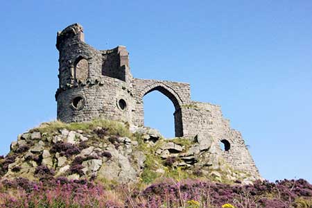
Click image to see photo description.
This walk from the village of Mow Cop, which straddles the Cheshire/Staffordshire boundary, provides the opportunity to explore Mow Cop Castle and the surrounding countryside. The Castle is a folly built in 1754 by Randle Williamson as a family summer house! Also of interest is the nearby gritstone rock formation known as the Old Man of Mow. The route follows paths and a section of the Macclesfield Canal. In addition, the views from Mow Cop are extensive across the Cheshire plain including Jodrell Bank.
The start is the National Trust car park just below the castle (grid ref. SJ857574). After parking exit at the rear of the parking area and follow the narrow path leading towards the left-hand side of the castle. After 100 metres turn left onto a narrow path through heather. This leads onto a track which in turn takes you to Castle Road. Turn right and after 250 metres turn left along a track (fingerpost on right side of road). Follow the track downhill. Continue ahead past a mast on your right to join the South Cheshire Way (grid ref. SJ859576).
Continue across fields to enter Hanging Wood. Exiting the trees, the path follows the edge the wood (on your right) and continues to reach a track just before Wood Farm. Reaching a junction, bear right and follow the farm access track to reach Yew Tree Lane (grid ref. SJ850589). After 100 metres, bear left through small gate and follow the path under the railway at Ackers Crossing. The path returns to join Yew Tree Lane. Reaching a T-junction, turn right along New Road and continue to reach a bridge over the Macclesfield Canal (grid ref. SJ847590). Turn right down steps to join the towpath. Bear right under the bridge and continue for just over three kilometres passing an extensive marina on your left after a kilometre.
Continue along the towpath to reach Hall Green lock. Cross the bridge and follow the path beside the railway to Moss Lane (grid ref. SJ835559). Turn left over the railway and continue for 400 metres to a T-junction. Cross thro ad with care to a stile and fingerpost. Follow the grassy track to Cob Moor Road (grid ref. SJ843559). Go straight across and take the path on the right through a broken stile. The path initially passes through trees before crossing fields to reach Newchapel Road (grid ref. SJ848554).
Turn left and after 50 metres turn left onto a footpath (adjacent to the High Street sign). The path runs behind houses on your right to cross a stile. Maintain direction across a large field aiming for a waymark ahead on the horizon. Continue downhill into a shallow valley and then rise again with a stone wall on your right. At the end of the field follow driveway to reach Mow Cop Road (grid ref. SJ851564). Turn right and almost immediately left over wooden stile to follow a path through heather.
Pass some high rocky outcrops on the right and at a path junction bear left (grid ref. SJ856522) and continue past a house up to a road. Turn right along Church Street, pass church on your left and where the road bends right continue ahead with the graveyard on your left. After 350 metres turn right at a footpath sign and continue up steps and then behind houses to reach Woodcock Lane with a telephone box and chapel on your left. Go straight ahead and then left at the next junction to follow High Street back to the start.
Maps 

| Ordnance Survey Explorer 268 | Sheet Map | 1:25k | BUY |
| Anquet OS Explorer 268 | Digital Map | 1:25k | BUY |
| Ordnance Survey Digital Map Subscription | |||
| Latest Ordnance Survey Discounts | |||
Other walks nearby
| Walk 2519 | The Cloud from Rushton Spencer | easy/mod | 9.0 miles |
| Walk 2604 | Dane Valley & Wincle from Rushton Spencer | moderate | 9.5 miles |
| Walk 2310 | The Cloud from Rushton Spencer (short route) | easy/mod | 5.0 miles |
| Walk 1288 | Roaches & Hen Cloud from Tittesworth Reservoir | moderate | 8.5 miles |
| Walk 2480 | Siddington & Redes Mere Circular | easy | 4.2 miles |
| Walk 2749 | Croker Hill Circular | easy | 4.0 miles |
| Walk 1371 | Rossendale Ramble from Sutton | moderate | 12.0 miles |
| Walk 1178 | Roaches and Lud's Church | moderate | 7.3 miles |
| Walk 1707 | The Roaches short circular | easy/mod | 5.0 miles |
| Walk 3030 | Roaches & Lud's Church | easy/mod | 7.0 miles |
