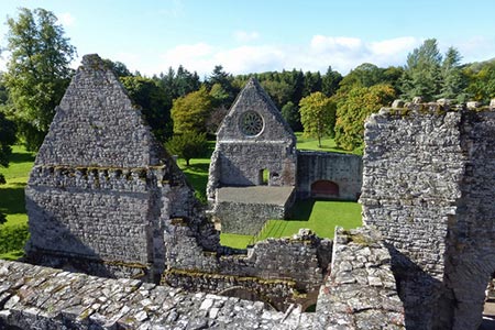
River Tweed & Dryburgh Abbey
Scottish Borders Walk
County/Area - Scottish Borders
Author - Lou Johnson
Length - 5.5 miles / 8.9 km Ascent - 600 feet / 182 metres
Time - 3 hours 20 minutes Grade - easy
Walk Route Description
Click image to see photo description.
This leisurely Scottish Borders walk starts from Dryburgh Abbey and follows the River Tweed downstream before crossing to the other side to pass through St Boswells. The route continues upstream and visits Wallace's Stature before returning to the start.
The start is the car park for Historic Scotland's Dryburgh Abbey where an admission charge is payable (grid ref. NT593318). Exit the car park the track to the right signed Borders Abbey Way passing toilets on your left. In 100 metres turn left over a stile and join the path with the River Tweed on your left. When the river bends to the right, the onward route follows a track climbing across the steep wooded riverbank. Co9ntinue into a field following path with field boundary on your immediate right with a mill below on your right. Reaching a junction, turn right to Mertoun Bridge soon descending steps to reach a road (grid ref. NT611321).
Turn right and cross the River Tweed. Just over the bridge take a flight of steps down on the right to join the St Cuthbert's Way. Continue on the path upstream with river on your right. Walk past a weir and after 1.5 kilometres pass a golf course on your left. Turn left along a surfaced track past the clubhouse to reach a lane. Two hundred and fifty metres past the clubhouse, turn right into Braeheads Road. You pass a fine stone-built house on the left complete with a turret. Continue with the high wall on your left and take the next lane on the left (also Braeheads Road).
Follow this lane to reach Main Street (B6404). Turn right and continue to pass public toilets on the left side of the road. Turn right along Hamilton Pace (following the St Cuthbert's Way sign on the lamp post). Turn right at another SCW sign, to fork left down a path just after a lamp post. Go left again down a flight of steps to reach the riverside path. Follow the path for just under a kilometre to reach a suspension foot bridge (grid ref. NT558320). Cross the bridge and pass the Temple of Muses on Bass Hill (on your left0> Follow the path around to the right and follow the lane for 300 metres to a road junction.
Turn left and just after the road swings right (by Newmains), take the path on the left. This leads up to Wallace's Statue. Retrace your steps down the path to the road, turn right and continue back to the junction passed a short while ago. Follow the road around to the left past the hotel entrance and return to the car park.
Maps 

| Ordnance Survey Explorer 338 | Sheet Map | 1:25k | BUY |
| Anquet OS Explorer 338 | Digital Map | 1:25k | BUY |
| Ordnance Survey Digital Map Subscription | |||
| Latest Ordnance Survey Discounts | |||
Other walks nearby
| Walk 2734 | The Eildon Hills | easy/mod | 5.3 miles |
| Walk 3293 | Three Brethren & Brown Knowe from Yarrowford | moderate | 8.3 miles |
| Walk 3296 | Grubbit Law & Hownam Law from Morebattle | moderate | 7.0 miles |
| Walk 1201 | Black Hag from Kirk Yetholm | moderate | 8.5 miles |
| Walk 1944 | Yarrow Valley Five Hills Circular | mod/hard | 11.4 miles |
| Walk 1894 | Burnhope Reservoir Circular | easy | 2.8 miles |
| Walk 2299 | The Cheviot | moderate | 9.0 miles |
| Walk 1314 | Great Hetha and Elsdon Burn from Hethpool | easy/mod | 4.0 miles |
| Walk 3644 | Blackhaggs Rigg & Great Hetha from Hethpool | moderate | 9.6 miles |
| Walk 3646 | Hethpool, Sutherland Bridge & Great Hetha | moderate | 6.0 miles |
Recommended Books & eBooks
Walking in the Southern Uplands
 Guidebook to 44 varied day walks and over 100 summits in the Southern Uplands of Scotland, stretching south-west from Edinburgh to the English border, including the Galloway and Pentland Hills. Between 2 and 29km, there is something for all seasons and all abilities in remote and rugged hill country.
More information
The Borders Abbeys Way
 Guidebook to the Borders Abbeys Way, a 68 mile circuit in the Scottish Borders, taking in 4 of Britain's grandest ruined medieval abbeys. Beginning and ending in Tweedbank, the route, which is described over 6 stages, is as rich in history as it is in pastoral charm. Relatively flat, it is suitable for people with a moderate level of fitness.
More information
