Three Brethren & Brown Knowe from Yarrowford
Scottish Borders Walk
County/Area - Scottish Borders
Author - Lou Johnson
Length - 8.3 miles / 13.5 km Ascent - 1800 feet / 545 metres
Time - 6 hours 0 minutes Grade - moderate
Walk Route Description
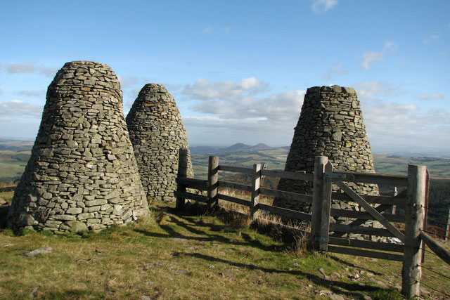
Click image to see photo description.
This walk from Yarrowford in the Southern Uplands climbs over Foulshiels Hill to join the Southern Upland Way. This is followed to the Three Brethren and onto Brown Knowe. From here the walk descends into valley along the Minchmoor Road along a pleasant ridge to return to Yarrowford. Good paths and tracks are used throughout the walk.
The start is the small parking area just west of the telephone box on the south side of the A708 in Yarrowford (grid ref. NT408299). After parking walk east and just before the bridge over Yarrow Water, turn left. After 70 metres, take a narrow path on the right which runs above a wooded gorge to reach Broadmeadows (a former Youth Hostel). Keep to the right of the house and continue above the burn to a gate in a wall at the end of the trees (grid ref. NT417306). Turn right and go through another gate to reach a grassy track. Turn right and after 60 metres turn left onto a clear gravel track (grid ref. NT418306).
This track climbs over a dip in the ridge of Foulshiels Hill to descend into the head of a broad valley where the track becomes less distinct and grassy. Continue ahead to a gate. Go through the gate and continue ahead to reach the edge of Forestry. Turn left and follow the Southern Upland Way north to Three Brethren (464 m.) with its cairns designating the boundaries of three estates. Continue along the SUW passing north of Broomy Law and south of the next top. The final ascent of the route takes you to Brown Knowe (523 m.) the highest point of the walk.
Cross the stile to the cairn and follow a feint descending path south to the right of a wall and fence. Continue down to the point where the fence and wall cross sides (grid ref. NT389323). Turn right here across and descend across grass to reach a grassy path (Minchmoor Road). Turn left and descend the ridge. As you make progress downhill, the path becomes a track over Hangingshaw Rig passing through several gates. Reaching a wood on the right continue to a gravel track on your right (grid ref. NT406304). Turn right and follow the track down to a tarmac road. Keep ahead passing the village hall to reach the main road in Yarrowford. Turn left back to the parking area.
Maps 

| Ordnance Survey Explorer 338 | Sheet Map | 1:25k | BUY |
| Anquet OS Explorer 338 | Digital Map | 1:25k | BUY |
| Ordnance Survey Digital Map Subscription | |||
| Latest Ordnance Survey Discounts | |||
Other walks nearby
| Walk 1944 | Yarrow Valley Five Hills Circular | mod/hard | 11.4 miles |
| Walk 2734 | The Eildon Hills | easy/mod | 5.3 miles |
| Walk 3576 | River Tweed & Dryburgh Abbey | easy | 5.5 miles |
| Walk 3759 | St. Mary's Loch Circular | easy/mod | 7.5 miles |
| Walk 2241 | Gladhouse Reservoir | easy | 4.0 miles |
| Walk 2006 | Grey Mare's Tail & White Coomb | mod/hard | 7.2 miles |
| Walk 2618 | Broad Law & Megget Stone | moderate | 5.0 miles |
| Walk 3612 | Ettrick Hills Horseshoe | mod/hard | 8.0 miles |
| Walk 3294 | Trahenna Hill from Broughton | moderate | 7.1 miles |
| Walk 2008 | Hart Fell via Saddle Yoke & the Black Hope Horseshoe | mod/hard | 8.5 miles |
Recommended Books & eBooks
The Borders Abbeys Way
 Guidebook to the Borders Abbeys Way, a 68 mile circuit in the Scottish Borders, taking in 4 of Britain's grandest ruined medieval abbeys. Beginning and ending in Tweedbank, the route, which is described over 6 stages, is as rich in history as it is in pastoral charm. Relatively flat, it is suitable for people with a moderate level of fitness.
More information
Walking in the Southern Uplands
 Guidebook to 44 varied day walks and over 100 summits in the Southern Uplands of Scotland, stretching south-west from Edinburgh to the English border, including the Galloway and Pentland Hills. Between 2 and 29km, there is something for all seasons and all abilities in remote and rugged hill country.
More information
