Yarrow Valley Five Hills Circular
Scottish Borders Walk
County/Area - Scottish Borders
Author - Chris Oakley
Length - 11.4 miles / 18.5 km Ascent - 2700 feet / 818 metres
Time - 8 hours 20 minutes Grade - mod/hard
Walk Route Description
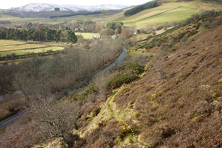
Click image to see photo description.
This Scottish Borders walk visits the summits of fine hills located either side of the Yarrow Valley which lies either side of the A708 a few miles west of Selkirk. The route is followed in a clockwise direction and should take about seven hours. Paths are indistinct, but sheep tend to choose the best route and they have made many trods across the hillsides.
The start is the triangle by Yarrow Bridge on the A708 at grid ref. NT357276. From here either walk towards Selkirk along the A708 or pass through the graveyard adjacent to the Kirk where there are many figures on the gravestones. Yarrow Kirk dates from the seventeenth century. Walk through the Kirkyard and back onto the A708 towards Deuchar. Continue past a row of cottages, head uphill through a bend and take the first gate on the left, which makes a distinct screech as you pull back the bolt.
Deuchar Hill, the first objective, is a mixture of troughs and mounds, with no clear path, so head up until you reach the near the top or the quad bike tracks, which tend to follow the ridge. The Deuchar Craig is a pile of rocks no higher than your ankles. From here, you can see Cat Craig, an easy walk over. From Cat Craig head for Old Hill, again choosing your own route. It has a gentle slope up and full of sheep the last time I was there. Continue next to Tanus Top and down onto the road at Old Tinnis. The road at Tinnus is dangerous. To walk down to Black Andrews Bridge via the road, you are hemmed in on both sides by high hawthorn bushes; difficult to avoid the logging lorries, so hop over the gate into the field and walk down to the Yarrowford straights. The bridge is on the bend of the road, so don't head towards Yarrowford.
From here we head away from the Yarrow river and do not return until near Yarrow on the return leg of the route. Cross Black Andrews Bridge and follow the clear gravel track until you come out of the trees to clear sky and fields over a cattle grid. There is a house on the right. Head for the clear path which takes you upwards. It's clear to see. Up you go. This is the detour of the Duchesses walk during Bow Hill logging operations. Eventually you come to the Duchess Walk. Keep the river to your right (it's far down in the valley). Keep on the path. Don't go left. This path wiggles and can give a sense of insecurity as it tends to back track, but it's okay.
Amongst the many gates, you come to one where the path goes left towards Bow Hill. There is a pile of gravel here also. Turn right and head towards Witchie Knowe with the view of The Eildon Hills behind you. The Eildon hills eventually disappear as you head closer to Witchie Knowe, at the top of The Squire. Here there's a good view of the Ettrick. The final descent is down the Squire and back to the car park.
There is an alternate route which follows 3 craigs down to the Yarrow River with Kershope farm on the left. It starts at no particular place (apologies), but there is a dip before Wichie Knowe, down to the final gate. If you reach the gate you have missed it. You have to bushwhack through tall grass and down towards the river, via 3 craigs. Out of the long grass, you cross a fence, head towards a worn-out barn (Easter Kershope) and follow the field next to Yarrow Water to a pebble beach. Hop over the fence, down to the beach, to the end of the beach and follow the river which leads to a defined path. This takes you past The Old Deuchar Bridge (sketched by Turner in his Edinburgh sketchbook in 1834) and along past the pheasantry following a delicate strip of fine old Scots pines and back to the car park.
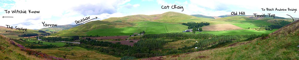
Panorama showing the Northern Half of the Yarrow Valley Walk - Photo Chris Oakley
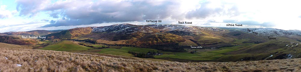
Panorama showing the Southern Half of the Yarrow Valley Walk - Photo Chris Oakley
Maps 

| Ordnance Survey Explorer 331 | Sheet Map | 1:25k | BUY |
| Anquet OS Explorer 331 | Digital Map | 1:25k | BUY |
| Ordnance Survey Digital Map Subscription | |||
| Latest Ordnance Survey Discounts | |||
Other walks nearby
| Walk 3293 | Three Brethren & Brown Knowe from Yarrowford | moderate | 8.3 miles |
| Walk 3759 | St. Mary's Loch Circular | easy/mod | 7.5 miles |
| Walk 2734 | The Eildon Hills | easy/mod | 5.3 miles |
| Walk 2006 | Grey Mare's Tail & White Coomb | mod/hard | 7.2 miles |
| Walk 2618 | Broad Law & Megget Stone | moderate | 5.0 miles |
| Walk 3576 | River Tweed & Dryburgh Abbey | easy | 5.5 miles |
| Walk 3612 | Ettrick Hills Horseshoe | mod/hard | 8.0 miles |
| Walk 3294 | Trahenna Hill from Broughton | moderate | 7.1 miles |
| Walk 2241 | Gladhouse Reservoir | easy | 4.0 miles |
| Walk 2008 | Hart Fell via Saddle Yoke & the Black Hope Horseshoe | mod/hard | 8.5 miles |
Recommended Books & eBooks
The Borders Abbeys Way
 Guidebook to the Borders Abbeys Way, a 68 mile circuit in the Scottish Borders, taking in 4 of Britain's grandest ruined medieval abbeys. Beginning and ending in Tweedbank, the route, which is described over 6 stages, is as rich in history as it is in pastoral charm. Relatively flat, it is suitable for people with a moderate level of fitness.
More information
Walking in the Southern Uplands
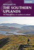 Guidebook to 44 varied day walks and over 100 summits in the Southern Uplands of Scotland, stretching south-west from Edinburgh to the English border, including the Galloway and Pentland Hills. Between 2 and 29km, there is something for all seasons and all abilities in remote and rugged hill country.
More information
