Shelton & Yelden from Upper Dean
Bedfordshire Walk
County/Area - Bedfordshire
Author - Lou Johnson
Length - 7.5 miles / 12.2 km Ascent - 300 feet / 91 metres
Time - 4 hours 0 minutes Grade - easy/mod
Maps 

| Ordnance Survey Explorer 224 | Sheet Map | 1:25k | BUY |
| Anquet OS Explorer 224 | Digital Map | 1:25k | BUY |
| Ordnance Survey Landranger 153 | Sheet Map | 1:50k | BUY |
| Anquet OS Landranger 153 | Digital Map | 1:50k | BUY |
Walk Route Description
Click image to see photo description.
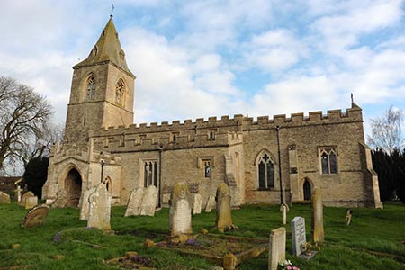
This Bedfordshire walk explores a quiet corner of this county with thatched cottages and quiet rural footpaths. The start is the pleasant village of Upper Dean with its fine parish church where parking is usually available opposite the church on High Street (grid ref. TL047676). Please be careful not to inconvenience residents when parking. The route continues to pass Shelton Hall before exploring the remains of a Motte and Bailey Castle at Yelden. Finally the walk passes through the village of Melchbourne before returning to the start.
To start the walk, take the enclosed path to the right-hand side of the church. This leads to Brook Lane. Turn left and continue a short way until you see a signed public footpath on your right. Take this path between neatly trimmed hedges to reach a field. Turn right and follow the boundary around to the left. Continue half right across the next field leading to the right of a building (grid ref. TL043679). Bear half left and follow a track with buildings to either side. Where this track bends sharp left, continue ahead on a path. This soon leads past a windmill on your right.
Continue straight across a field and join a clear track. Continue ahead across three fields to reach a small area of woodland (grid ref. TL035684). Continue ahead with the trees to your right to pass Shelton Hall before continuing between a barn and some stables to pass through the stable yard to reach a lane (grid ref. TL037682).
Turn left down the lane to follow the Three Shires Way. You soon reach a T-junction. Bear left and stay on the Three Shires Way keeping to the right at the first junction of tracks. You now have just over a mile to walk along the Three Shires Way to reach the main road through Yelden (grid ref. TL013671).
Turn left along the road. Continue past the grassed remains of a Motte and Bailey Castle on your right. Turn right onto a signed footpath Follow the yellow markers through the castle grounds. Continue uphill to a yellow pole by a stile in the fence. Cross the stile and then turn left. Continue along the path with the hedge to your immediate left. After 300 metres the hedge bends to the left. At this point continue straight ahead to reach a small wooded area. Pass through the trees and turn right.
Keep the wooded area to your immediate right and continue for about 400 metres. Turn left on a vague path that heads to a red brick building which is part of Crowfield Farm (grid ref. TL018661). Continue straight ahead past the barns to join a track with the field boundary hedge to your left. The track bends left, then right and left again around Barton's Spinney before bearing left and then right to reach a Knotting Road (grid ref. TL026655).
Cross the road and continue along the footpath opposite. This path follows the field boundary which should be on your left. The path leads out onto Park Road. Turn left and continue through the village of Melchbourne to a T-junction. Turn right and continue north along the road for about 450 metres to reach another T-junction (grid ref. TL030662). Cross straight over to join a signed bridleway. After 150 metres turn right on an unmarked permissive bridleway. This path keeps the field boundary on your left and soon turns left to head north by-passing Grange Farm way to your left. Joining a better track, keep heading in the same direction until you reach Dean Lodge (grid ref. TL034673). Turn right here just before the house and follow a path and then their access drive to a road (grid ref. TL041672).
Turn left along the road which swings right to enter the village. Ignore Brook Lane on your left and continue until you reach High Street which is a left turn. A short way further and you are soon back at the start.
Other walks nearby
| Walk 2133 | Graffham Water | easy/mod | 7.8 miles |
| Walk 3271 | Grafham Water Circular | easy/mod | 8.7 miles |
| Walk 1798 | Little Paxton & River Ouse Circular | easy/mod | 6.4 miles |
| Walk 2477 | Alconbury Weston & Buckworth Circular | easy | 6.9 miles |
| Walk 1974 | Lyveden New Bield from Wadenhoe | easy/mod | 8.2 miles |
| Walk 3623 | Wood Walton Circular | easy | 4.1 miles |
| Walk 2123 | Everton & Potton | moderate | 12.0 miles |
| Walk 2714 | Between Beeston and Old Warden | easy/mod | 11.5 miles |
| Walk 3113 | Sandy and Everton Circular | easy/mod | 7.5 miles |
| Walk 2305 | Gamlingay, Tetworth & Everton from Potton | easy/mod | 9.5 miles |
Recommended Books & eBooks
No suggestions for this area.Messaging & Social Media
Message Walking Britain and follow the latest news.

Mountain Weather
Stay safe on the mountains with detailed weather forecasts - for iOS devices or for Android devices.