Newtown (Y Drenewydd), Brimmin Wood & Kerry
Powys Walk
County/Area - Powys - Powys North
Author - Walking Newtown
Length - 8.3 miles / 13.5 km Ascent - 1300 feet / 394 metres
Time - 5 hours 30 minutes Grade - moderate
Walk Route Description
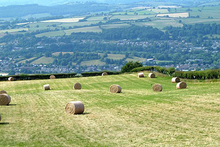
Click image to see photo description.
This Powys walk from Newtown (Y Drenewydd) explores the countryside lying south-east of the town. The route follows paths, tracks and country lanes exploring the picturesque landscape of this area. The walk is strenuous in places with many ups and downs. The walk can be shortened by omitting the detour to Kerry which will reduce the distance by 2.5 miles (4 km.) and save some ascent.
1 - Start at the Town Clock at the junction of Broad St, High St, and Severn St. Walk along Shortbridge St passing Market St and the Post Office, on your right, and the Robert Owen statue in the small park on your left. Cross Pool Road (A483) at the traffic lights and continue up Old Kerry Road to the Victorian buildings of Agriculture House and Royal Welsh Warehouse. If you are starting at the pub, The Railway Tavern (01686 626156), it is here on the right. If you come by train, start the walk at Brimmon Lane (see below).
2 - At Agriculture House cross the road and take the small lane, Brimmon Lane, that takes you over the railway line near Newtown station. Turn left and continue up this lane to the road, Heol Treowen. Cross the road to the lane opposite and continue a little way until you reach a cattle grid on your right. Go over the cattle grid then follow the track over two more cattle grids and under the by-pass up to the house and farm buildings ahead. Continue up between the barns and go through the field gate on the right onto the green lane. Walk up the track with the wood on your left, hedge on the right, through another field gate, until you come to a shoulder of the hill, with two adjacent oak trees on your right and a way-marked path joining from the left.
3 - Turn sharp left here (SO 114904) follow the path along the top of the wood. Go through the field gate ahead and continue in the same direction with the hedge on your left. Go through three more field gates until you come to a half- timbered house, Shwrwd.
1 - Walk up the drive to the right and continue until you reach the road (SO 122907). Turn right and go up the road until you reach a T junction. Cross the road and go up the bank and through the gate immediately in front of you. Carry straight on through the field with the hedge on your right, go down the dip, through the field gate and up the hill following the hedge straight on to another field gate visible at the top. Go through the gate and bear left towards another field gate across the field under an oak tree. With the fence/hedge on your left, go straight ahead to the end of the field.
5 - Go through the gate on your left, turn sharp right and through the right hand one of the two field gates. Take the track between two fences, down through the next right-hand field gate and then head straight down the dip in the field ahead of you in the direction of the white house on the hill facing you.
6 - At the bottom of this field a fingerpost marks the junction of five footpaths (SO 130898). We call this Five Ways, and it is where the main circular walk begins the return. This is the start of the Kerry detour.
To return, with your back to the Five Ways fingerpost, facing the stile below, take the upper track to your right. Follow the contour of this large field, and an indistinct sheep track to a fence and a small group of conifers up slightly to the right and at right angles to your path (SO 124898). Cross the stile or go through the adjacent field gate and bear left, with the fence on your left. At the next stile go straight ahead, again with a fence on your left, through a field gate. Walk diagonally up the field and as you come over the brow you will see a stile ahead. Cross this stile and head towards the black corrugated iron barn ahead. The path continues to the right of this barn and the house, Pen y Wern. Cross another stile and follow the fence on your left until you can cross a stile onto the track. Turn right, go up the drive then through the field gate at the top.
7 - Turn left onto the road and go through the first gate on the right (SO 115894). Bear left towards the conifers and a large oak, on which the Montgomery Barn Owl Group (www.mbog.co.uk) have put an owl box. Go through the gate to the right of the oak and follow the track downhill between the conifers and hedge. A gate at the bottom brings you into another field with a gate ahead that leads on to a lane. Take the lane down to the road, by a sign for Lower Black Hill. Go through the gate on your right and follow the hedge on your left, skirting the old green lane which is too overgrown to walk down. At the bottom left-hand corner of the field is a pedestrian gate (SO 111896). Carry straight on downhill and through the gate ahead. With the wood on your right, go through the gate in the corner and follow the cypress hedge on your left to the gate and road. Turn right. The next part can be muddy in places and an alternative route would be to follow this road into Newtown.
8 - Leave the road after a short distance, turning right at the drive to a bungalow, Hillside (SO 110899). Take the field gate and grassy lane ahead with the wood on your right. Go through a field gate, cross a small stream and through another field gate. Continue ahead with the hedge line on your right. Cross a farm track with a field gate on your left (do not take this one) and go slightly up to your right and then through the next field gate. Cross the stream and follow the hedge and fence to your left. Just after you cross another two streams a gate on your left leads into a field. Bear right and down to the way-marker marking the green lane that descends to the two oak trees where you left it near the beginning of the walk. Retrace your steps to the house and farmyard at Upper Brimmon and back along the tarmac track under the by-pass and over the cattle grids to the road. Turn left, cross Heol Treowen and back to town.
Detour to Kerry
At the Five Ways signpost, cross the stile ahead and bear left towards Kerry (visible in the distance) to a field gate in the bottom corner. Go through and follow the hedge on your right to another field gate on the right, along a short, overgrown green lane on to the road. Turn left and walk to the T junction at the main Newtown to Kerry road turning right over Gilfach bridge and then into the village. The Kerry Lamb (01686 670226) and the Herbert Arms (07977 181729) open during the day on Saturday and Sunday. St Michaels Church has an unusual double-nave with a large west tower and a timber-framed belfry. It also has one of only three chained Welsh bibles in Wales.
To return, retrace your steps to Five Ways and follow the return directions from there. To return by bus, use the Tanat Valley service (no. 81 from Montgomery) Mon to Sat. See the notice board at the stop, call Traveline Cymru at 0871 2002233 or visit the web site www.traveline.cymru/
A detailed hand-drawn route map showing details of the route - Newtown to Brimmon Wood and Kerry Route Map
Maps 

| Ordnance Survey Explorer 215 | Sheet Map | 1:25k | BUY |
| Anquet OS Explorer 215 | Digital Map | 1:25k | BUY |
| Ordnance Survey Digital Map Subscription | |||
| Latest Ordnance Survey Discounts | |||
Other walks nearby
| Walk 3253 | Warren Hill, Gors Lydan & Moelfre Hill | easy/mod | 6.0 miles |
| Walk 1785 | Newcastle on Clun circular | moderate | 7.5 miles |
| Walk 1898 | Severn Valley from Llanidloes | moderate | 11.3 miles |
| Walk 2471 | Clun Valley Circular | easy/mod | 8.1 miles |
| Walk 3266 | The Dingle & Y Golfa from Welshpool | easy/mod | 6.6 miles |
| Walk 2814 | Corndon Hill from Priest Weston | easy | 1.5 miles |
| Walk 2472 | Abbeycwmhir Circular | easy/mod | 7.2 miles |
| Walk 3050 | Clun circular | moderate | 11.5 miles |
| Walk 1809 | Shelve & the Stiperstones from The Bog | moderate | 9.0 miles |
| Walk 2083 | Linley Hill and Linley from The Bog | moderate | 8.5 miles |
Recommended Books & eBooks
The Cambrian Way
 Guidebook to the Cambrian Way, a challenging three-week mountain trek through Wales from Cardiff to Conwy. The 470km un-waymarked route is presented from south to north. Often sticking to long, beautiful ridgelines, it crosses wild and rugged terrain and visits many of Wales's highest mountains, including Snowdon.
More information
