Summits 1-50 Summits 51-100 Summits 101-150 Summits 151-200 Summits 201-258
Snowdon
Walking Guide and Walks
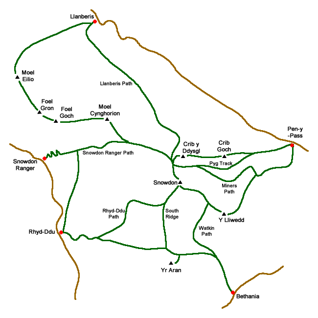
Snowdon (Welsh: Yr Wyddfa) at 1085 metres above sea level is the highest mountain in Wales. Located in the Snowdonia National Park it is a very busy mountain especially on the paths from Pen-y-Pass and Llanberis. The view from the summit is superb in good weather with Ireland, Scotland, England and the Isle of Man in the extensive panorama.
There are eight main routes to Snowdon's summit.
The Llanberis Path - the longest route and the least steep which mainly follows the Snowdon Mountain Railway. For many this is the least interesting and easiest way to the top.
Snowdon Ranger Path - climbs from the western side of the mountain and is generally much less trodden than the routes from the east. Path starts with easy zig-zags before climbing to follow the ridge above Clogwyn Du'r Arddu towards the summit.
Rhyd Ddu Path - another quieter route from the west that is one of the easiest walks to the summit eventually joining the South Ridge for the final section to the top.
Watkin Path - seen by many as the most demanding route the walk starts from Bethania and offers a scenically interesting way up the mountain.
Over Y Lliwedd - is part of the Snowdon Horseshoe walk and is usually done as a means of descent from Snowdon.
Miners' Track - starting from Pen-y-Pass it is the most popular route up the mountain sharing the latter stages of the ascent with the Pyg Track.
Pyg Track - taking a higher route than the Miners' Path this route also provides the initial part of the Crib Goch Route.
Crib Goch route - a head for heights and some scrambling skills are needed to traverse one of the finest ridge walks in Britain. It is also the first stage of the Snowdon Horseshoe Walk and includes the summit of Crib y Ddysgl.
List of walks
★ GPS file available ☩ Route profile
| Walk | Description | Grade | Miles |
|---|---|---|---|
| 2122★☩ | Cwm Glas from Pen-y-pass | mod/hard | 4.00 |
| 1136★☩ | Yr Aran (Route 2) | moderate | 5.50 |
| 1192★☩ | Yr Aran | mod/hard | 6.50 |
| 3073★☩ | Crib Goch, Garnedd Ugain and Snowdon from Pen-y-pass | hard | 6.50 |
| 3057★☩ | Moel Eilio from Llanberis | moderate | 7.00 |
| 2729★☩ | Snowdon by Rhyd-Ddu and Snowdon Ranger Paths | mod/hard | 7.50 |
| 1418★☩ | Snowdon and Y Lliwedd from Pen-y-pass | mod/hard | 7.50 |
| 1958★☩ | The Snowdon Horseshoe from Pen-y-pass | hard | 7.50 |
| 1216★☩ | Y Lliwedd & Snowdon from Pen-y-pass | mod/hard | 7.50 |
| 1089★☩ | Snowdon by the Pyg and Miner's Tracks | moderate | 7.50 |
| 3198★☩ | Snowdon via the South Ridge & Rhyd-ddu Path | mod/hard | 7.50 |
| 2692★☩ | Snowdon via Dinas Mot & Crib Goch from Pen-y-pass | hard | 8.00 |
| 2290★☩ | Snowdon via the Watkin Path & South Ridge from Bethania | mod/hard | 8.00 |
| 3036★☩ | Snowdon via Crib Goch from Pen-y-pass | very hard | 8.50 |
| 2797★☩ | Yr Aran and Snowdon from Rhyd-Ddu | mod/hard | 8.50 |
| 1003★☩ | Snowdon by the Llanberis Path | moderate | 9.00 |
| 2626★☩ | Snowdon & Garnedd Ugain from Llanberis | moderate | 9.30 |
| 1681★☩ | Moel Eilio & Moel Cynghorion | mod/hard | 10.00 |
| 1103★☩ | Snowdon & Cwm Llan horseshoe | very hard | 13.00 |
| 3059★☩ | Moel Cynghorion & Snowdon from near Llanberis | very hard | 13.50 |
| 3002★ | Welsh Three-Thousanders from Pen-y-Pass | severe | 31.50 |
Table of summits in the Snowdon Group
| Rank | Mountain | Metres/Feet | Location |
|---|---|---|---|
| 1 | Snowdon | 1085 / 3560 | Snowdonia |
| 2 | Garnedd Ugain | 1065 / 3494 | Snowdonia |
| 17 | Crib Goch | 923 / 3028 | Snowdonia |
| 23 | Y Lliwedd | 898 / 2946 | Snowdonia |
| 98 | Yr Aran | 747 / 2451 | Snowdonia |
| 111 | Moel Eilio | 726 / 2382 | Snowdonia |
| 169 | Moel Cynghorion | 674 / 2211 | Snowdonia |
Digital Maps - Copyright © 2011-2024. All rights reserved.
Map showing main paths and starting points.
Messaging & Social Media
Message Walking Britain and follow the latest news.

Mountain Weather
Stay safe on the mountains with detailed weather forecasts - for iOS devices or for Android devices.