Watersmeet & Foreland Point from County Gate
Exmoor Walk
Nat Park - Exmoor
County/Area - Devon
Author - Lou Johnson
Length - 10.5 miles / 17.1 km Ascent - 3630 feet / 1100 metres
Time - 8 hours 50 minutes Grade - mod/hard
Walk Route Description
Click image to visit gallery of 10 images.
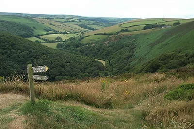
This walk, which stays within the County of Devon, contains four main elements including excellent valley paths, mature woodland, upland pastures and a spectacular section of the South West Coast Path that runs high above the shoreline. The start is the car park (Grid ref. SS793486) alongside the Exmoor National Park visitor centre at County Gate on the A39 between Porlock and Lynmouth. It is not an easy walk with a total ascent similar to many high mountain routes and it is worth noting that it involves a steep ascent right at the end. As a bonus, route finding is easy as Exmoor is noted for its high standard of signing.
From the car park take the signed path heading west to Brendon. Immediately you have the benefit of a fine view ahead as you descend gently for nearly two miles into the valley containing the East Lyn River. The path reaches a lane in Brendon. Turn left along the lane ignoring the road crossing the river to locate a signed footpath on your left leading to Watersmeet. This is a delightful section mainly in deciduous woodland and follows the river as it heads towards the sea. At times the path climbs above the river before dropping down to continue alongside it.
Stay on the path as far as Watersmeet where there are refreshments in season. Having explored the pretty spot where the two rivers meet, retrace your steps a short way back towards Brendon and locate a path on your left signed 'Contisbury'. This path climbs easily in a series of zigzags to lead you out of the woodland into open pasture and down to the A39. Turn left, taking care as this is a busy road, and cross to the car park. Exit the car park and continue north through the churchyard onto the South West Coast Path.
The onward section of path is straightforward. However it is worth mentioning that the effort to climb the short distance to the summit of the Foreland is rewarding as it offers a great spot to rest and take in the view. You also need to be mentally tuned to the idea that you still have plenty of climbing to do although admittedly its mostly in short sections. The switchback nature of the Coast Path is offset by the tremendous views as you steadily make progress east towards Porlock.
As one might expect the signage is good and you stay on the South West Coast Path for about three miles (5 km) to reach a cottage on your right in the Glenthorne Plantation. Passing this first obvious sign of habitation since leaving Contisbury, stay on the drive for a short way before descending left on the waymarked path. This leads you back to the track from where a signed path to 'County Gate' heads steeply uphill. If you have surplus energy then you can take the longer alternative route signed 'County Gate - Nature Trail' but most will opt for the direct route back to the start. As you struggle uphill you will certainly have reason to be pleased with yourself as you have completed a challenging and scenically delightful walk in the North Devon sector of the Exmoor National Park.
Maps 

| Ordnance Survey Explorer OL9 | Sheet Map | 1:25k | BUY |
| Anquet OS Explorer OL9 | Digital Map | 1:25k | BUY |
| Ordnance Survey Digital Map Subscription | |||
| Latest Ordnance Survey Discounts | |||
Other walks nearby
| Walk 1263 | The Doone Valley | moderate | 8.5 miles |
| Walk 3729 | Foreland Point | moderate | 5.0 miles |
| Walk 1910 | Countisbury and Watersmeet from Lynmouth | easy/mod | 4.5 miles |
| Walk 3391 | Valley of Rocks frrom Lynton | easy/mod | 3.8 miles |
| Walk 3386 | Barle Valley & Cow Castle from Simonsbath | easy/mod | 6.4 miles |
| Walk 1221 | Selworthy Beacon & North Hill from Bossington | moderate | 8.5 miles |
| Walk 1727 | Shallowford, Hoar Oak Tree & The Chains | moderate | 11.7 miles |
| Walk 2387 | Pinkery Pond Circular | easy/mod | 5.8 miles |
| Walk 3390 | Heddon Valley from Woody Bay | moderate | 5.3 miles |
| Walk 2451 | Withypool & Barle Valley | easy/mod | 6.0 miles |
Recommended Books & eBooks
The South West Coast Path
 Guidebook to walking the entire South West Coast Path National Trail. The route runs for 630 miles from Minehead to Poole along the north Devon, Cornish, south Devon and Dorset coastline. Divided into 45 stages, this long-distance coastal trek could be completed within 4 weeks, or walked in sections. Guide includes maps and essential information.
More information
South West Coast Path Map Booklet - St Ives to Plymouth
 Map of part of the southern section of the 630 mile (1014km) South West Coast Path National Trail. Covers the trail from St Ives to Plymouth along the west Cornwall and Devon coastline. This convenient and compact booklet of Ordnance Survey 1:25,000 maps shows the route, providing all of the mapping you need to walk the trail in either direction.
More information
