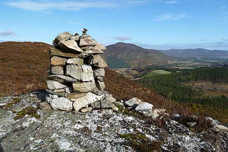
Creagan an Fhithich from Falls of Truim
Cairngorms Walk
Nat Park - Cairngorms - Cairngorm North
County/Area - Highland
Author - Lou Johnson
Length - 6.3 miles / 10.2 km Ascent - 760 feet / 230 metres
Time - 4 hours 0 minutes Grade - easy/mod
Walk Route Description
Click image to see photo description.
This Cairngorm National Park walk explores the hills rising to the west of the A9 at the Falls of Truim. In spate the falls are worth a visit in their own right although the climb up to the viewpoint on Creagan an Fhithich adds another dimension to the walk with fine views across the upper reaches of the Spey Valley. The start is the small carpark signed off the A9 just under five miles south of Newtonmore.
Leave the carpark and walk back towards the main road to take the lane leading up to Crubenbeg. Continue through the gate on the right following the Falls of Truim path, which leads down via steps to the Falls. After enjoying the spectacle return up the path to the road. Continue towards Crubenbeg crossing General Wade's bridge. Go immediately right through a gate high above the River Truim, which is down to your right. Follow the waymark, turning left away from the river and walk through woodland to reach a junction. Turn right and then left at the next junction. After crossing a field, turn right onto a farm track. Walk past a house, go through a gate and immediately bear left onto a pat. Stay on the path crossing a track to reach a building. Go left through a gate and continue climbing to another track.
Turn right along the ascending track. Reaching the top turn left onto a path following the left hand edge of the field. Go through the gap in the fence and turn left than right onto the ole Perth Road. On your left rise the slopes of Cruban Beag and Cruban Mor. There are also good views along the Spey valley. The track descends to a gate and starts to climb again passing a track on your right. At grid ref. NN678939) turn left onto a path signed to Truim Woods Viewpoint. After an initial section through woodland the path climbs steeply in places to reach the viewpoint of Creagan an Fhithich from where the views more than compensate for your efforts.
To continue, retrace your steps down from the viewpoint and continue as far as the main track. Tur right and then go left past the barrier into Truim Woods. Continue along the wide forest track. Bear left at the fork and continue down to a minor road (grid ref. NN685945). Turn right and follow the lane for about 800 metres across the River Truim and the railway line. Turn right onto the mixed use cycle-path and footpath and continue for about 3 km back towards the next road (leading to Dalwhinnie and Crubenbeg). Turn right over the railway and return to the carpark where you started.
Maps 

| Ordnance Survey Explorer OL56 | Sheet Map | 1:25k | BUY |
| Anquet OS Explorer OL56 | Digital Map | 1:25k | BUY |
| Ordnance Survey Digital Map Subscription | |||
| Latest Ordnance Survey Discounts | |||
Other walks nearby
| Walk 3255 | Coire Ardair | moderate | 7.5 miles |
| Walk 1906 | Lochan Mor & Rothiemurchus Forest from Inverdruie | easy/mod | 3.6 miles |
| Walk 1505 | Craigellachie National Nature Reserve | easy/mod | 5.0 miles |
| Walk 3354 | Glen Banvie and Blair Castle from the Falls of Bruar | moderate | 11.3 miles |
| Walk 1721 | Braeriach via Lairig Ghru | hard | 18.2 miles |
| Walk 3299 | Loch an Eilein from Coylumbridge | easy/mod | 7.0 miles |
| Walk 1016 | Devil's Point, Cairn Toul, Braeriach & Lairig Ghru | very hard | 28.0 miles |
| Walk 2067 | Rothiemurchus Forest via Balvattan from Coylumbridge | easy/mod | 4.6 miles |
| Walk 3076 | Cairn Toul Circular | severe | 26.5 miles |
| Walk 1881 | Ben Macdui & Cairn Lochan from the Ski Centre | hard | 10.4 miles |
Recommended Books & eBooks
Skye's Cuillin Ridge Traverse
 This 2-volume set provides all the information required to complete the main ridge traverse on Skye's Black Cuillin. Strategy, gear, training, navigation and logistics are covered, and 10 classic scrambles are described. A lightweight second guidebook gives the scrambler detailed maps, topos and route description for the ridge traverse itself.
More information
Great Mountain Days in Scotland
 Inspirational guidebook to 50 challenging routes for mountaineers, scramblers, hillwalkers and fell runners, many long enough to backpack over 2 days, especially in winter (12 to 25 miles). A mix of classic routes and unsung gems across Scotland from Galloway to the Outer Hebrides in widely differing wild landscapes. With customised OS mapping.
More information
