Grey Mare's Tail & White Coomb
Dumfries and Galloway Walk
County/Area - Dumfries and Galloway
Author - Simon Tweedie
Length - 7.2 miles / 11.7 km Ascent - 2450 feet / 742 metres
Time - 6 hours 0 minutes Grade - mod/hard
Walk Route Description
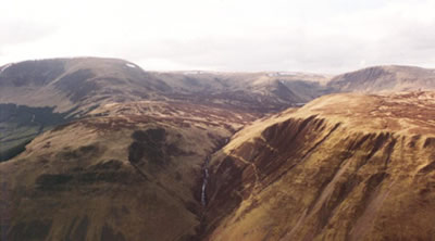
Click image to visit gallery of 4 images.
The walk starts from the car park of the Grey Mare's waterfall, which is ten miles north east of the pretty town of Moffat on the A708 to Selkirk (grid ref NT186145). The drive to the start of the walk provides ample evidence of the wild terrain in these parts and this walk gives at least an introduction to the many opportunities for walking in the area.
From the car park take the steep path on the north side. This path climbs fast offering great views of the Grey Mare's Tail waterfall as you gain height. the path exits into the hanging valley above and you follow the Tail Burn as it meanders through the moraines.
In a short time the wee jewel of Loch Skene appears as if by magic. The route traces the eastern shore of the Loch to Lochcraig Head, which is clearly in view ahead. Another steep climb up a grassy slope to the right of the screes leads up to the summit cairn of Lochcraig Head.
Beyond the cairn is an old dry stane dyke (stone wall) which leads westerly at first to Firthybrig Head and then continues to the Corbett of White Coomb. The summit of White Coomb (821 metres) is 100 paces to the south west of the old dyke. On a clear day the fells of the Lake District are visible over the Solway. Continue on following the dyke as it drops east to Upper Tarnberry. There is a short bit of scrambling on this section but no major difficulties should be encountered.
Eventually the dyke leads back to the Tail Burn. There is a boulder in the burn just up stream from the end of the dyke which makes a useful crossing point. You are now back on the path above the falls. Retrace your steps down past the Mare's Tail. Take care and do not be tempted to stray off the route. There have been tragedies in the past especially after rain and snow.
Maps 

| Ordnance Survey Explorer 330 | Sheet Map | 1:25k | BUY |
| Anquet OS Explorer 330 | Digital Map | 1:25k | BUY |
| Ordnance Survey Digital Map Subscription | |||
| Latest Ordnance Survey Discounts | |||
Other walks nearby
| Walk 3612 | Ettrick Hills Horseshoe | mod/hard | 8.0 miles |
| Walk 2008 | Hart Fell via Saddle Yoke & the Black Hope Horseshoe | mod/hard | 8.5 miles |
| Walk 2618 | Broad Law & Megget Stone | moderate | 5.0 miles |
| Walk 3759 | St. Mary's Loch Circular | easy/mod | 7.5 miles |
| Walk 2045 | Capel Fell via Sailfoot Law & Broken Back Hill | moderate | 5.8 miles |
| Walk 2035 | Hart Fell via Hartfell Spa | moderate | 7.2 miles |
| Walk 2280 | Hart Fell & Whitehope Heights | moderate | 8.4 miles |
| Walk 2050 | The Crown of Scotland | moderate | 9.0 miles |
| Walk 2268 | Annandale Way | moderate | 9.0 miles |
| Walk 2135 | Camps Reservoir Circular | easy | 5.8 miles |
