St. Mary's Loch Circular
Scottish Borders Walk
County/Area - Scottish Borders
Author - Lou Johnson
Length - 7.5 miles / 12.2 km Ascent - 700 feet / 212 metres
Time - 4 hours 30 minutes Grade - easy/mod
Walk Route Description
Click image to see photo description.
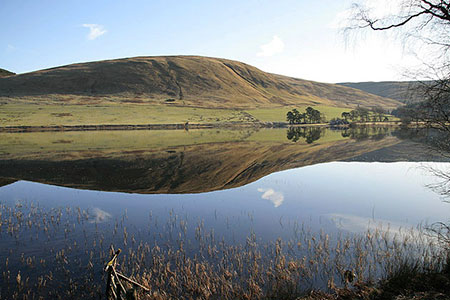
This walk in the Scottish Borders provides a pleasant half day circuit around St Mary's Loch which lies beside the A708 midway between Moffat and Selkirk. The loch is largest natural loch in Southern Scotland and was originally much larger with the Loch of the Lowes once an integral part of a single loch. The loch lies in a beautiful location surrounded by hills. The outward route follows a section of the Southern Upland Way before crossing to the north side of the loch for a return via St. Mary's churchyard.
The start is the parking area (grid ref. NT238204) at the southern end of the loch near Tibbie Shiels Inn and close to the James Hogg Monument. After parking walk briefly north beside the A708 and take the first tarmac lane on the right. Cross the bridge and continue through the Tibbie Shiels Inn carpark to join the Southern Upland Way which is followed for four kilometres to the eastern end of the loch.
Reaching the parking area at the end of the loch, cross the bridge over Yarrow Water and turn left. The route briefly follows the loch shore before turning right beside a stone wall back to the A708. Turn left and almost immediately cross the road with care to a stile with a fingerpost. You are following a drove road which runs above and roughly parallel to the A708. After about a kilometre you will reach a signpost pointing uphill to the right. Follow this path up to St, Mary's Kirkyard from where there is an excellent view.
Continue back down to the drove road and turn right (west) to follow the grassy track through to the small settlement of Cappercleuch where the path re-joins the A708. Turn right and follow the grass verge beside the A708 back to the start.
Maps 

| Ordnance Survey Explorer 330 | Sheet Map | 1:25k | BUY |
| Anquet OS Explorer 330 | Digital Map | 1:25k | BUY |
| Ordnance Survey Digital Map Subscription | |||
| Latest Ordnance Survey Discounts | |||
Other walks nearby
| Walk 2006 | Grey Mare's Tail & White Coomb | mod/hard | 7.2 miles |
| Walk 2618 | Broad Law & Megget Stone | moderate | 5.0 miles |
| Walk 3612 | Ettrick Hills Horseshoe | mod/hard | 8.0 miles |
| Walk 2008 | Hart Fell via Saddle Yoke & the Black Hope Horseshoe | mod/hard | 8.5 miles |
| Walk 1944 | Yarrow Valley Five Hills Circular | mod/hard | 11.4 miles |
| Walk 2045 | Capel Fell via Sailfoot Law & Broken Back Hill | moderate | 5.8 miles |
| Walk 2035 | Hart Fell via Hartfell Spa | moderate | 7.2 miles |
| Walk 2280 | Hart Fell & Whitehope Heights | moderate | 8.4 miles |
| Walk 2050 | The Crown of Scotland | moderate | 9.0 miles |
| Walk 3293 | Three Brethren & Brown Knowe from Yarrowford | moderate | 8.3 miles |
Recommended Books & eBooks
Walking in the Southern Uplands
 Guidebook to 44 varied day walks and over 100 summits in the Southern Uplands of Scotland, stretching south-west from Edinburgh to the English border, including the Galloway and Pentland Hills. Between 2 and 29km, there is something for all seasons and all abilities in remote and rugged hill country.
More information
The Borders Abbeys Way
 Guidebook to the Borders Abbeys Way, a 68 mile circuit in the Scottish Borders, taking in 4 of Britain's grandest ruined medieval abbeys. Beginning and ending in Tweedbank, the route, which is described over 6 stages, is as rich in history as it is in pastoral charm. Relatively flat, it is suitable for people with a moderate level of fitness.
More information
