Hart Fell via Saddle Yoke & the Black Hope Horseshoe
Dumfries and Galloway Walk
County/Area - Dumfries and Galloway
Author - Simon Tweedie
Length - 8.5 miles / 13.8 km Ascent - 3000 feet / 909 metres
Time - 7 hours 20 minutes Grade - mod/hard
Walk Route Description
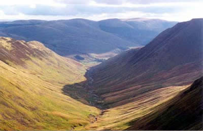
Click image to visit gallery of 4 images.
This relatively tough excursion in the Southern Uplands of Scotland provides superb views and a challenging route. Park by the Black Hope cottage near Capplegill farm (grid ref. NT148098) about 7 miles from Moffat on the A708 Selkirk road. Pass through the gate next to the cottage and follow the farm track until a second gate is reached. Strike off up the grassy shoulder of Saddle Yoke. There is no defined path and the gradient is unremitting for 1500ft.
From the summit of Saddle Yoke the route drops down dramatically to a narrow grassy edge which forms a bridge across to Upper Saddle Yoke. From here carry on over the open moorland and peat hags down to Whirly Gill. From here follow the top of Saddle Craigs and continue up to Hart Fell, which provides a superb viewpoint of the glen and the route you are following.
The return journey is along the west leg of the horseshoe and skirts the tops of Hart Fell, Falcon, Coomb and Black Craigs. The best views are had close to the top of the cliffs although do take care if the visibility is poor. Of particular note is an interesting arete called the Hound Shoulder on Coomb Craigs. Not to be outdone Black Craig has a fine little grassy pinnacle which stands proudly above the Black Hope Glen some 1500ft below. It is well worth a visit but take care especially when it is slippery underfoot.
The descent to Capplegill is reasonably straight forward though the finish is steep. Care is needed to avoid Hang Gill, which is clearly marked on the Ordnance Survey map.
Maps 

| Ordnance Survey Explorer 330 | Sheet Map | 1:25k | BUY |
| Anquet OS Explorer 330 | Digital Map | 1:25k | BUY |
| Ordnance Survey Digital Map Subscription | |||
| Latest Ordnance Survey Discounts | |||
Other walks nearby
| Walk 2045 | Capel Fell via Sailfoot Law & Broken Back Hill | moderate | 5.8 miles |
| Walk 3612 | Ettrick Hills Horseshoe | mod/hard | 8.0 miles |
| Walk 2006 | Grey Mare's Tail & White Coomb | mod/hard | 7.2 miles |
| Walk 2035 | Hart Fell via Hartfell Spa | moderate | 7.2 miles |
| Walk 2280 | Hart Fell & Whitehope Heights | moderate | 8.4 miles |
| Walk 2050 | The Crown of Scotland | moderate | 9.0 miles |
| Walk 2268 | Annandale Way | moderate | 9.0 miles |
| Walk 2618 | Broad Law & Megget Stone | moderate | 5.0 miles |
| Walk 3759 | St. Mary's Loch Circular | easy/mod | 7.5 miles |
| Walk 2135 | Camps Reservoir Circular | easy | 5.8 miles |
