Hart Fell via Hartfell Spa
Dumfries and Galloway Walk
County/Area - Dumfries and Galloway
Author - Simon Tweedie
Length - 7.2 miles / 11.7 km Ascent - 2200 feet / 667 metres
Time - 5 hours 50 minutes Grade - moderate
Walk Route Description
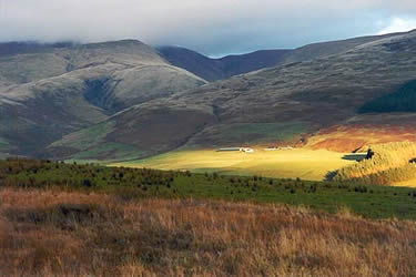
Click image to see photo description.
The walk starts a few miles from Moffat. Driving north through the town on the A701 turn right by Moffat Academy just as the main road takes a sharp left. Follow this road for about three miles until you come to the isolated corrugated building of Annan Water Hall on your right (grid ref. NT075104). There is a small parking space adjacent to the hall.
Hartfell Spa is signposted a few yards north of the hall. Cross the fields then Auchencat Burn can be followed but it entails crossing the burn on some fairly 'dodgy' wooden footbridges. There is an easier path just to the north and higher up on the flank of Well Rig. Either way continue to Hartfell Spa which is a chalybeate spring contained within a small stone structure. Legend has it that Merlin the Magician spent his final years living here before the locals killed him at Drummelzier a few miles north on the Tweed.
You can scramble on up the Spa Well Burn but it is very steep and loose in places with some strange geological features giving an almost Martian feel, quite unlike the surrounding hills. If you wish it is possible to retrace your steps few hundred yards and climb up the flank of Well Rig avoiding the steep section above the Spa.
Continue onwards and upwards over Arthur's Seat until the fence line is reached. If you cross the fence take care as the steep cliffs of Hartfell Craig are not far beyond though the view down the Black Hope Glen is worth it on a clear day. Otherwise follow the fence line northwesterly to the summit of Hart Fell.
There are a number of choices as to return routes. The easiest being is to retrace the route up but an alternative is to descend via Hartfell Shoulder to the west picking up the Lochan Burn and then back to the road.
Maps 

| Ordnance Survey Explorer 330 | Sheet Map | 1:25k | BUY |
| Anquet OS Explorer 330 | Digital Map | 1:25k | BUY |
| Ordnance Survey Digital Map Subscription | |||
| Latest Ordnance Survey Discounts | |||
Other walks nearby
| Walk 2050 | The Crown of Scotland | moderate | 9.0 miles |
| Walk 2268 | Annandale Way | moderate | 9.0 miles |
| Walk 2045 | Capel Fell via Sailfoot Law & Broken Back Hill | moderate | 5.8 miles |
| Walk 2008 | Hart Fell via Saddle Yoke & the Black Hope Horseshoe | mod/hard | 8.5 miles |
| Walk 3612 | Ettrick Hills Horseshoe | mod/hard | 8.0 miles |
| Walk 2006 | Grey Mare's Tail & White Coomb | mod/hard | 7.2 miles |
| Walk 2618 | Broad Law & Megget Stone | moderate | 5.0 miles |
| Walk 2135 | Camps Reservoir Circular | easy | 5.8 miles |
| Walk 3759 | St. Mary's Loch Circular | easy/mod | 7.5 miles |
| Walk 3752 | Tinto from Wiston (southern approach) | moderate | 4.2 miles |
