Capel Fell via Sailfoot Law & Broken Back Hill
Dumfries and Galloway Walk
County/Area - Dumfries and Galloway
Author - Simon Tweedie
Length - 5.8 miles / 9.4 km Ascent - 2000 feet / 606 metres
Time - 4 hours 50 minutes Grade - moderate
Walk Route Description
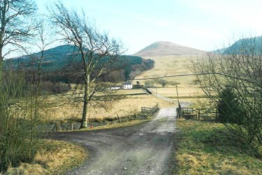
Click image to visit gallery of 3 images.
The walk starts 5 miles north east of Moffat on the A708 at the Selcoth Fish Farm. There is limited parking at the entrance of the farm (Grid ref. NT136079).
This walk is a good introduction to the Moffat Hills as it climbs quite high to 678m but the going is not too steep or strenuous. There are some great views of the hills on the other side of Moffat Dale across to Black Hope and Saddle Yoke (see walk 2008).
Starting at the entrance to the Selcoth fish farm, follow the farm track over the bridge and past Sailfoot house continuing up through the forest to the top. The track divides halfway up. You can take either way as they meet at the top in the col between Sailfoot Law and Capel Fell.
It is worth taking a small detour to Sailfoot Law for the views below. Retracing your steps back to the forestry track follow the quad bike track that runs straight up to the fence at the summit of Capel Fell. Hopefully you will be rewarded with some stunning views over Ettrick Forest where the outlaw William Wallace spent much time hiding out.
Continue along the fence line in a south easterly direction until you meet the fence that runs west towards Broken Back Hill. Avoiding the steep ground that drops down to Bill Cleuch lose height down to the twin humps of Broken Back. Keeping left towards the Selcoth Burn, pick up the foot path that runs through the fish farm and back to the road
Maps 

| Ordnance Survey Explorer 330 | Sheet Map | 1:25k | BUY |
| Anquet OS Explorer 330 | Digital Map | 1:25k | BUY |
| Ordnance Survey Digital Map Subscription | |||
| Latest Ordnance Survey Discounts | |||
Other walks nearby
| Walk 2008 | Hart Fell via Saddle Yoke & the Black Hope Horseshoe | mod/hard | 8.5 miles |
| Walk 3612 | Ettrick Hills Horseshoe | mod/hard | 8.0 miles |
| Walk 2035 | Hart Fell via Hartfell Spa | moderate | 7.2 miles |
| Walk 2280 | Hart Fell & Whitehope Heights | moderate | 8.4 miles |
| Walk 2050 | The Crown of Scotland | moderate | 9.0 miles |
| Walk 2006 | Grey Mare's Tail & White Coomb | mod/hard | 7.2 miles |
| Walk 2268 | Annandale Way | moderate | 9.0 miles |
| Walk 2618 | Broad Law & Megget Stone | moderate | 5.0 miles |
| Walk 3759 | St. Mary's Loch Circular | easy/mod | 7.5 miles |
| Walk 2135 | Camps Reservoir Circular | easy | 5.8 miles |
