Dove Crag & Red Screes - Scandale Horseshoe
Lake District Walk
Nat Park - Lake District - Lake District Eastern Fells
Wainwrights - Dove Crag, High Crag, Low Crad, Red Screes
County/Area - Cumbria
Author - Lou Johnson
Length - 9.5 miles / 15.4 km Ascent - 3000 feet / 909 metres
Time - 7 hours 50 minutes Grade - mod/hard
Walk Route Description
Click image to see photo description.
This Lake District walk uses part of the popular Fairfield horseshoe as far as Dove Crag before descending east to Scandale Pass before ascending Red Screes. The return to Ambleside follows a generally easy descent onto the road from Kirkstone Pass to Ambleside. Generally route finding is easy and should the weather close in then a quick return to Ambleside can be made by following the path down Scandale.
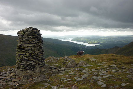
From the centre of Ambleside take the Kirkstone Road for a short way from the A591 turning down the first lane on the left to Nook End Farm. This leads easily to Low Sweden Bridge from where the views of the Fells begin to improve. The onward path to Low Pike is well-trodden and you soon find yourself alongside the ridge wall. This leads onwards over High Pike and on towards Dove Crag. As you climb, the views on both sides are excellent and improve with each step. Reaching the cairn on the summit of Dove Crag it is worth heading a little farther north to enjoy the view. This is also an ideal spot to take a break before the next section of the route.
To continue retrace your steps for about 400 metres along the eastern side of the wall to locate a path descending east and following a line of old fence posts. A short diversion south to the cairns on High Bakestones is a worthwhile addition to the route. Continue following the old fence which leads you past Little Hart Crag the summit of which is another worthwhile diversion. The path continues in a south-easterly direction passing to the east of Scandale Tarn down to Scandale Pass. In bad weather a right turn here will lead easily and fairly quickly back into Ambleside.
The route continues across Scandale Pass initially following a collapsed wall up stony slopes to the summit of Red Screes. Reaching a cross wall (also collapsed) make a beeline for the summit cairn from there are excellent views. In particular the view east to the Far eastern Fells is one of my favourites. To complete the route descend from Red Screes heading south-west soon passing a tarn on your right. The route continues over Raven Crag following the ridge down to Snarker Pike. The descent from this point heads towards a pair of parallel walls. The path continues to descend and exits onto the road from Kirkstone Pass down to Ambleside. Turn right along this road, and taking care, head back down into Ambleside.
Maps 

| Ordnance Survey Explorer OL5 | Sheet Map | 1:25k | BUY |
| Anquet OS Explorer OL5 | Digital Map | 1:25k | BUY |
| Ordnance Survey Explorer OL7 | Sheet Map | 1:25k | BUY |
| Anquet OS Explorer OL7 | Digital Map | 1:25k | BUY |
| Ordnance Survey Digital Map Subscription | |||
| Latest Ordnance Survey Discounts | |||
Other walks nearby
| Walk 2026 | Loughrigg from Pelter Bridge near Rydal | easy/mod | 4.0 miles |
| Walk 3034 | Red Screes & Other Fells from Ambleside | mod/hard | 10.0 miles |
| Walk 3697 | Loughrigg Fell from Skelwith Bridge | easy/mod | 4.5 miles |
| Walk 1823 | Fairfield Horseshoe & Loughrigg from High Close | mod/hard | 14.0 miles |
| Walk 1472 | Alcock Tarn & Rydal Water | easy/mod | 7.0 miles |
| Walk 1565 | Rydal Water & Grasmere circular | easy/mod | 6.0 miles |
| Walk 1682 | Rydal Water & Grasmere | easy/mod | 5.5 miles |
| Walk 2715 | Skelwith Bridge & Loughrigg | easy/mod | 5.5 miles |
| Walk 1684 | Lingmoor Fell & Langdale | easy/mod | 7.0 miles |
| Walk 1141 | Elterwater circular | easy/mod | 4.0 miles |
Recommended Books & eBooks
The Cumbria Way
 A guidebook to the 73 mile Cumbria Way, an easy long-distance walk though the heart of the Lake District National Park, from Ulverston in the south to Carlisle in the north, with good transport links to either end. The route is largely low-level but this guide offers alternative mountain days to climb some of the famous fells en route.
More information
Lake District: Low Level and Lake Walks
 This guidebook describes 30 of the best low-level walks in the Lake District. From delightful wooded glades and sparkling tarns, to waterfalls and glacier-carved valleys towered over by craggy mountains. The walks described aim to seek out the best walking that the lower areas of the Lake District have to offer.
More information
