Scarborough Walks and Walking Guide
North York Moors, North Yorkshire
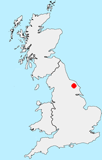
Find circuylar walks near Scarborough which is situated on the North Sea coast just outside the southern border of the North York Moors National Park. It is an ideal centre for those who wish to explore the moors and coast of this wonderful National Park. The town has excellent local amenities including cafés, bars and restaurants. Accommodation in the area is varied including campsites and caravan parks. Public transport does provide links to some of the walks in this beautiful area and there is a rail service from York.
All walks are free to download and print, and all routes have mapping and GPX files. The highlights are walks along the coast from Robin Hood's Bay as far south as Flamborough Head in neighbouring East Yorkshire. Other areas worth exploring are the moors with many walks offering wonderful views into the dales that bisect the landscape.
★ = GPS file available
| Walk | Description | Grade | Miles |
|---|---|---|---|
| 3533★ | Mallyan Spout and Beck Hole from Goathland | easy | 3.00 |
| 3337★ | Dundale Pond from Levisham | easy | 4.80 |
| 3534★ | Dundale Pond & Hole of Horcum from Saltergate | easy/mod | 5.20 |
| 3428★ | Boynton from Rudston Circular | easy | 6.50 |
| 2921★ | Bempton Cliffs from Flamborough | easy/mod | 6.70 |
| 1464★ | Sleights Moor from Blue Moor | easy/mod | 7.75 |
| 3247★ | Stockingdale and Muston from Hunmanby | easy/mod | 7.80 |
| 1395★ | Broxa & Broxa Forest | easy/mod | 8.25 |
| 1397★ | Hole of Horcum from Levisham Station | easy/mod | 8.50 |
| 3471★ | Robin Hood's Bay from Ravenscar | moderate | 8.50 |
| 1744★ | Hayburn Wyke & Ravenscar along the Cleveland Way | moderate | 8.50 |
| 1743★ | Sneaton Thorpe & Littlebeck from May Beck | moderate | 8.90 |
| 1620★ | Flamborough Head from Flamborough | easy/mod | 9.70 |
| 2130★ | Robin Hood's Bay & Hawkser from Fylingthorpe | moderate | 10.00 |
| 1623★ | Burn Howe Rigg from Jugger Howes | moderate | 10.00 |
| 2325★ | Troutsdale Circular | moderate | 10.10 |
| 1631★ | Scarborough to Filey | moderate | 10.20 |
| 1564★ | Hayburn Wyke from Scalby | moderate | 10.20 |
| 1396★ | Hole of Horcum and Saltergate Brow from Lockton | moderate | 10.25 |
| 1758★ | Newton House Plantation & Stony Leas | moderate | 10.30 |
| 2583★ | Iburndale and the Esk Valley from Stainsacre | moderate | 10.30 |
| 1630★ | Filey, Camp Dale & Hunmanby | moderate | 10.50 |
| 1922★ | Goathland & Howl Moors | moderate | 11.20 |
| 1930★ | Wheeldale Moor circular | moderate | 11.30 |
| 1602★ | Saltergate, Fylingdales & Allerston High Moor | moderate | 11.50 |
The walks listed above are the nearest 25 from Scarborough when measured in a straight line.
Recommended Reading
Trail and Fell Running in the Yorkshire Dales
 Guidebook to 40 of the best trail and fell runs in the Yorkshire Dales National Park. Ranging from 5 to 24 miles, the graded runs start from bases such as Ribblehead, Dent, Sedbergh, Malham and Grassington and take in the region's diverse delights, from castles and waterfalls to iconic mountains such as Whernside, Ingleborough and Pen Y Ghent.
More information
Further Information
Walk Location Map

Walking in North York Moors
Walking in the North York Moors National Park combines dramatic coastal scenery and wild upland moorland with beautiful rural scenery and interesting villages. In addition to these basic ingredients, there are many points of interest from industrial heritage to ruined abbeys and a steam railway. With a well developed network of footpaths and bridle ways this National Park provides a wonderful range of walks. More Information
Walk grading - Learn how each walk is assessed and select a walk to suit your ability and experience by going to Walk Grading Details.
Mountain Weather
Stay safe on the mountains with detailed weather forecasts - for iOS devices or for Android devices.

